Forest fires are an ever-growing topic of concern. At BCIT, researchers are combining Remotely Piloted Aircraft System (RPAS) – better known as “drones” – with a field of Artificial Intelligence (AI) known as “computer vision” to try to prevent and improve forest fire management. Computer vision involves a computer deriving information and data from visual input like images and videos.
BCIT Computing’s Dr. Michal Aibin completed a PhD focused on optical networks, and he’s been working on projects that apply computer vision to natural resource sustainability since 2021. “I came to this work because I wanted to use my expertise to make a difference in the world,” he explains. “My role involves developing algorithms and models that make it easier to collect and analyze data from different terrains.”
And the team is making significant progress. “Currently, Canada spends around $400 million annually on post-wildfire operations. If we can allocate just 10% of that budget to prevention strategies, we could potentially prevent 30-40% of wildfires,” explains Michal.
“The ultimate goal of our work is to help build safer, more resilient communities and ecosystems.” – Dr. Michal Aibin
Improving fire prediction and management

Michal recently received a two-year Natural Sciences and Engineering Research Council of Canada (NSERC) grant for a project that aims to improve how we map forest fires and potential fire locations.
“Traditional methods use ground sensors, aerial surveillance with planes or helicopters, and satellites,” says Michal. “But each of these has its drawbacks like high costs, time consumption, and weather interference.”
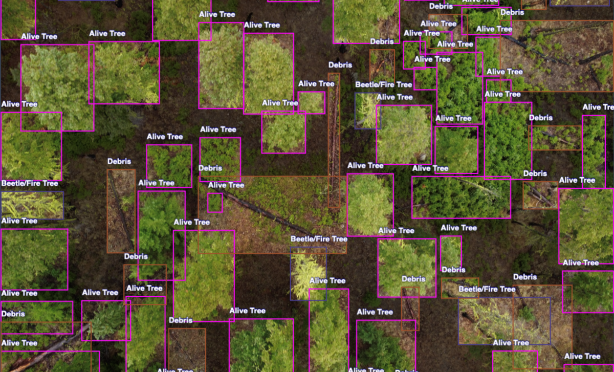
So the team – which includes industry partner Spexi Geospatial – is using drones to take detailed images of forests and label them for fire risk. The resulting maps help forestry managers understand and predict where fires might start. Instead of detecting fires, or working in post-wildfire operations, the focus is on predicting flammability of specific regions, based on frequently updated high-resolution drone imagery.
“They can then test different strategies to reduce fire risks, which will help make fire management more efficient and effective,” says Michal. “The ultimate goal of our work is to help build safer, more resilient communities and ecosystems.”
Multi-layered interdisciplinary work
This work is complex. Collecting high-quality data from drones across different terrains and weather conditions is challenging, and they need consistent, reliable data to make accurate predictions.
“Developing and fine-tuning machine learning models that can accurately detect and predict forest fire risks is also complex, especially since we’re using advanced techniques to process raw image data,” reports Michal. “This interdisciplinary work combines expertise from AI, environmental science, and remote sensing, and coordinating between these different fields is complicated.”
BCIT students and other faculty members are heavily involved in the project, with some students funded as research assistants. “Additionally, we plan to recruit talented students from the new Master of Science Applied Computing program that starts next year, which will be very important for bringing the best talent in BC into our project.
Results are promising
“We have developed a proof of concept that uses computer vision algorithms to detect forest fire risks, and our approach shows promising results in improving the accuracy of models,” says Michal. They’ve also advanced post-wildfire assessment techniques, and are thus better able to analyze and classify burnt and unburnt areas. “Our initial tests have been successful, and we are now working on refining and optimizing these models for real-world application.”
They’re expanding data collection efforts, capturing more diverse and high-resolution imagery from different terrains and weather conditions. “Recruiting talented students and collaborating with industry and community partners will be key to advancing our research and applying our findings to practical scenarios,” says Michal.
“I’m excited about the progress we’ve made and look forward to seeing the tangible benefits of this rewarding work.”
Learn more about Michal’s research and work with drones.
Featured photo: raw drone image overlaid with computer-vision processing
The research topic is incredibly relevant to our community, where there’s a high demand for this technology. It’s inspiring to see BCIT involved in this important work. As a CST student with a strong interest in this area, I would love the opportunity to contribute to projects like this in the future. Wishing you great success in advancing wildfire research.
Interesting article! If you want to read more about Dr. Aibin’s work with drones and image-detection AI, see this write-up on the RPAS Hub section of the website: https://www.bcit.ca/learning-teaching-centre/remotely-piloted-aircraft-systems/industry-collaboration/real-time-image-detection-for-search-and-rescue/